Close this alert
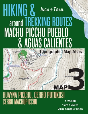
Inca Trail Map 3 Hiking & Trekking Routes around Machu Picchu Pueblo & Aguas Calientes Topographic Map Atlas Huayna Picchu, Cerro Putukusi, Cerro Mach (Travel Guide Hiking Trail Maps Cusco Peru)
Current price:
$14.95
This product is not returnable.
Publication Date: February 22nd, 2018
Publisher:
Createspace Independent Publishing Platform
ISBN:
9781985786684
Pages:
44
Usually Ships in 1 to 5 Days
Description
Updated edition. Large scale, highly detailed topographic map 1:25.000 for hiking and trekking, printed as an atlas book (with overlapping pages).
Covers the area around Machu Picchu Pueblo & the town of Aguas Calientes, including Cerro Putukusi, the mountain close to Aguas Calientes, on the northeast side of the Urubamba River, which offers epic views of Machu Picchu and the surrounding Urubamba River valley.
20 meter contour lines, road network, trails & paths, transportation, food, campsites, shelters, guest houses & hotels.Mercator projection with both UTM and WGS84 coordinate grids.
The map scale of 1:25000 (1 cm = 250 meters) provides a wealth of detail while keeping low the weight of the atlas itself. The large page format of 8.5x11in minimizes page count and along with an overlapping map design allows for comfortable navigation.
The details included in the topographic maps of this atlas were specifically selected to be useful for trekkers, hikers and walkers of all interests, and make it easy to plan and enjoy both short excursions and hikes as well as long multi-day adventures along the main marked routes and/or adjacent trails and paths, which are also shown on the maps.
With this ultralight atlas you will always have a detailed, reliable, information-rich, battery-independent, shatter-proof map for your adventure.
Other Books in Series
Inca Trail Map 1 Hiking & Trekking Routes to Machu Picchu Topographic Map Atlas Choquequirao Trek, Salkantay/Mollepata, Vilcabamba, Santa Teresa, Huan (Travel Guide Hiking Trail Maps Cusco Peru)
Paperback
Inca Trail Map 2 Hiking & Trekking Routes to Machu Picchu Topographic Map Atlas Cusco, Sacred VAlley, Lares Trek, Salkantay Trek, Urubamba, Pisac, Qui (Travel Guide Hiking Trail Maps Cusco Peru)
Paperback