Close this alert
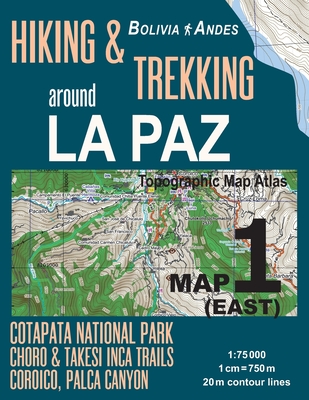
Hiking & Trekking around La Paz Map 1 (East) Cotapata National Park, Choro & Takesi Inca Trails, Coroico, Palca Canyon Bolivia Andes Topographic Map A
Current price:
$14.95
This product is not returnable.
Publication Date: February 28th, 2018
Publisher:
Createspace Independent Publishing Platform
ISBN:
9781986014168
Pages:
46
Usually Ships in 1 to 5 Days
Description
Updated edition. Detailed topographic map 1:75.000 for hiking and trekking, printed as an atlas book (with overlapping pages).
Covers the area to the north-east of the city of La Paz, Bolivia, including the Parque Nacional y Area de Manejo Integrado Cotapata, the village of Coroico and surround area with beautiful hikiing trails, the Inca Trails from Santa Rosa to Chulumani and from Choquecota to Campamento Minero Chojlla (Yanacachi), also known as the Choro and Takasi treks; the Palca Canyon to the south-east of La Paz; as well as other trails and paths.
20 meter contour lines, road network, trails & paths, transportation, food, campsites, shelters, guest houses & hotels.Mercator projection with both UTM and WGS84 coordinate grids.
The map scale of 1:75000 (1 cm = 750 meters) provides a wealth of detail while keeping low the weight of the atlas itself. The large page format of 8.5x11in minimizes page count and along with an overlapping map design allows for comfortable navigation.
The details included in the topographic maps of this atlas were specifically selected to be useful for trekkers, hikers and walkers of all interests, and make it easy to plan and enjoy both short excursions and hikes as well as long multi-day adventures along the main marked routes and/or adjacent trails and paths, which are also shown on the maps.
With this ultralight atlas you will always have a detailed, reliable, information-rich, battery-independent, shatter-proof map for your adventure.
Other Books in Series
A Walk in the Woods: Rediscovering America on the Appalachian Trail
Paperback
LunarTale (An Abrams Trail Tale): A New Year's Adventure
Board book
EidTale (An Abrams Trail Tale): An Eid al-Fitr Adventure
Board book
Hiking America's National Parks (Great Hiking Trails)
Hardcover
Top Trails: Great Smoky Mountains National Park: 50 Must-Do Hikes for Everyone
Paperback
Pacific Crest Trail: Northern California: From Tuolumne Meadows to the Oregon Border
Paperback
The Oregon Trail: Danger at the Haunted Gate
Paperback
Pacific Crest Trail: Oregon & Washington: From the California Border to Canada
Paperback
Zion National Park Map (National Geographic Trails Illustrated Map #214)
Folded
Rail-Trails Southern New England: The Definitive Guide to Multiuse Trails in Connecticut, Massachusetts, and Rhode Island
Paperback
Top Trails: Lake Tahoe: 59 Must-Do Hikes for Everyone
Paperback
Rail-Trails California: The Definitive Guide to the State's Top Multiuse Trails
Paperback
The Oregon Trail: The Race to Chimney Rock
Paperback
Five-Star Trails: Spokane: 30 Spectacular Hikes in the Inland Northwest
Paperback
Top Trails: Northern California's Redwood Coast: 59 Must-Do Hikes for Everyone
Paperback
Five-Star Trails: Columbus: Your Guide to the Area's Most Beautiful Hikes
Paperback
Preorder
Redeeming the Maverick (Montana Mavericks: The Trail to Tenacity #1)
Mass Market Paperbound
Five-Star Trails: Louisville & Southern Indiana: 40 Spectacular Hikes in the Derby City Region
Paperback
Rail-Trails Northern New England: The Definitive Guide to Multiuse Trails in Maine, New Hampshire, and Vermont
Paperback
The West Highland Way: Milngavie to Fort William Scottish Long Distance Route (UK long-distance trails series)
Paperback